
7 TOP FREE SATELLITE IMAGERY SOURCES IN 2019

أفضل سبعة مواقع لتحميل صور فضائية مجانية
We live in a wonderful era when absolutely anyone can access the latest free satellite images of Earth; it only takes to know where you can find them. Our best seven free GIS data sources list will make it easier to decide which of the available web services has the data you need.
1. USGS EARTH EXPLORERالموقع الأول
The USGS agency has the longest record of collecting free GIS data (free satellite images, aerial, UAV ), which is made available via their EarthExplorer .
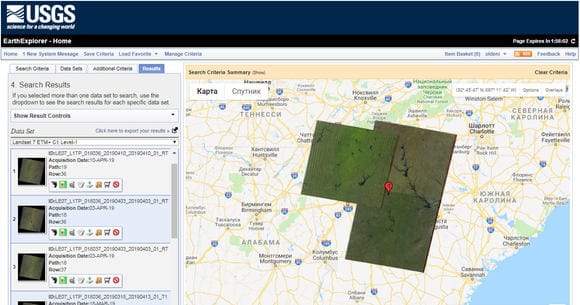
Imagery. The selection of free satellite imagery in EarthExplorer is overwhelming: from optical and radar data to weather satellite images to digital elevation maps. You will find there 40 years’ worth of free satellites images from USGS-NASA Landsat missions, and a diversity of data from other NASA remote sensors (Terra and Aqua MODIS, ASTER, VIIRS, etc.). It also features open source datasets provided under collaboration with ISRO (Resourcesat-1 and 2), ESA (Sentinel-2), and some commercial high-resolution satellite data (IKONOS-2, OrbView-3, historical SPOT data).
Search. EarthExplorer allows you to narrow down the search for free satellite imagery by area, date, cloud cover %, and include as many sensors as you want. All the found tiles can be conveniently previewed one by one or all at once.
On top of the standard Area of Interest selection options (address, coordinates, file upload or drawing), the interface offers a feature-based search, which is pretty fun to test. You can find all possible features, even less common ones ‒ like ancient roads or graves ‒ anywhere in the world.
Download. For USGS free satellite image download , you will need to install the Bulk Download Application. Depending on the sensor, various data products can be downloaded (Level-1,2,3, Natural color imagery, Thermal imagery, etc.).
Analysis. EE can be used for search, preview, and free GIS data download purposes only. If you want to analyze images, you will need special software.
EarthExplorer is an undisputed leader among free satellite imagery sources in terms of data variety but not the most user-friendly service, especially to a non-expert. It may take a while to familiarize yourself with all the buttons, menu options, and datasets available. So be prepared that your first search for satellite images can be quite time-consuming.
2. LANDVIEWERالموقع الثاني
LandViewer is a free GIS database with an easy-to-master interface that gives access to the most widely used satellite imagery, allows high resolution satellite imagery free previews and ordering, and features many tools for image analysis.
Imagery. LandViewer offers miscellaneous free global satellite images. You can get most up to date satellite images from Landsat 7-8, Sentinel-1 and 2, CBERS-4, MODIS, aerial data from NAIP, or get Landsat 4-5 historical satellite imagery. It also features an impressive list of high resolution satellite images free for search and preview, and available for purchase. Some of the datasets you can get there include SPOT 5-7, Pleiades-1, Kompsat-2, 3, 3A, SuperView-1; the best spatial resolution comes up to 40 cm per pixel.
Search. The search is very simple and straightforward: once you set the Area of Interest using one of the multiple options (including file upload), select the type of sensor and pick the dates. Additionally, you can apply cloud cover %, Sun elevation, and AOI coverage % filters. Make sure to save your Area of Interest and subscribe to new scenes ‒ this great feature will save a lot of time in the future.
Download. When it comes to downloading data, LandViewer has a lot to offer. Let’s imagine you’ve come for free Landsat satellite images download , what are your options? First, you can download a full or manually cropped Natural color Landsat image in JPEG, KMZ or GeoTIFF. If you need only specific spectral bands, use the second option to get only those you will use. And the third option is downloading a processed image: a band combination or a calculated index.
If you don’t want to store images on PC, save them to cloud EOS Storage or use WMS feature to streamline satellite data to desktop GIS software.
Analysis. Unlike most free satellite imagery sources, LandViewer enables instant visualization and analysis of the data you’ve found. Over 20 default band combinations and indexes such as NDVI, NBR, SAVI, the raster calculator-like custom index builder, time series analysis, clustering, and more of its tools are meant to help extract the value from satellite images free.
LandViewer is the best satellite imagery source for GIS beginners and experts from other industries (agriculture, forestry, construction) who don’t use special GIS software and are looking for free updated satellite imagery with fast and accurate analytics included.
3. COPERNICUS OPEN ACCESS HUBالموقع الثالث
Formerly the “Sentinels Scientific Data Hub”, the ESA’s open access portal is able to quench anyone’s thirst for Sentinel data.
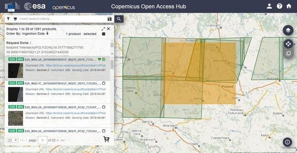
Imagery. Currently, Copernicus Open Access Hub brings to users the latest free satellite images from all active Sentinels: radar imagery from Sentinel-1, optical multispectral Sentinel-2 imagery, Sentinel-3 land products for environmental monitoring, and atmosphere and air quality data from Sentinel-5P.
Search. Copernicus Hub’s interface is very laconic, which doesn’t necessarily mean convenient. You can’t upload a file with your AOI, and to run a search by coordinates you have to type in a text query using specific operators . For example, to apply the cloud cover filter you need to enter “[0 to 5]”. It does make sense for professionals but is difficult to digest for non-experts.
Download. To download recent satellite images free, you just need to add them to the Cart.
Analysis. There are no analytical tools or even image visualization on a map. You can only preview a tile in the “Quicklook” mode alongside very detailed metadata.
Copernicus Open Access Hub can be recommended as a source of all the Sentinels’ free satellite imagery . However, if you’re after data from Sentinel-1 or 2, consider trying out other data sources offering the same images with a slightly better user experience.
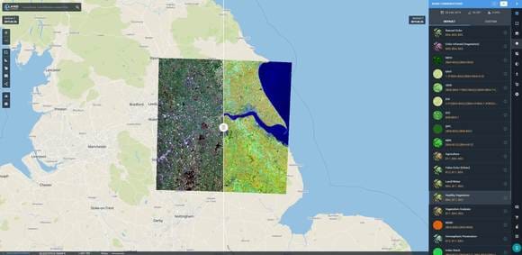
4. SENTINEL HUBالموقع الرابع
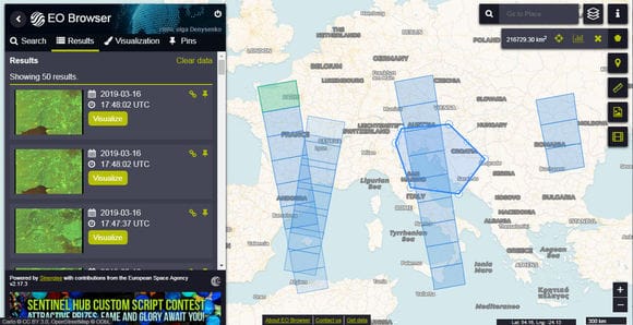
Sentinel Hub provides access to a wide range of open source satellite imagery via its two services: EO Browser and Sentinel Playground.
Imagery. EO Browser holds around a dozen of medium and low-resolution satellite imagery sets, including complete archives of all the Sentinel missions, Landsat 5-7,8, MODIS, Envisat Meris, Proba-V, and GIBS products. Sentinel Playground, in its turn, contains a satellite imagery mosaic of the globe derived from Sentinel-2, Landsat 8, MODIS or DEM.
Search. Both services have an intuitive interface and convenient search. EO Browser offers all the basic search filters to ease the image discovery. The only caveat is that some datasets are only rendered at a certain scale: for example, Landsat image won’t start showing until a 20-km zoom.
Download. With Sentinel Playground, you can obtain parts of the mosaic (JPEG); EO Browser enables the downloading of full-resolution images in various formats (JPEG, KMZ, GeoTIFF) or separate bands and band combinations.
Analysis. EO Browser has the tools for satellite imagery visualization and analysis. For instance, for a Sentinel-2 image, you can select one of 8 band combinations and indexes, as well as create your own. It can also generate the time series, but compared to other services (e.g., LandViewer), it won’t let you visualize all the images used.
EO Browser is an easy-to-master web service with a decent selection of free medium-resolution satellite imagery. One of its advantages is the ability to analyze and visualize image data. Sentinel Playground is more of a for-fun service for exploring and sharing fragments of the satellite imagery mosaic of the world.
5. NASA EARTHDATA SEARCHالموقع الخامس
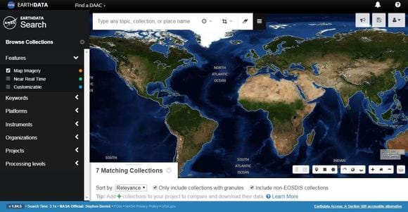
NASA’s Earthdata Search provides online access to multiple collections of NASA’s EOSDIS data (Earth Observing System Data and Information System).
Imagery. In Earthdata Search, you will find a plethora of NASA Earth science data from different sources – satellites, aircraft, field measurements, including other programs. The amount of free current satellite images and historical imagery enlisted in the “Platforms” tab is impressive: Aqua and Terra, ENVISAT, GOES, NOAA satellites, METEOSAT, Suomi-NPP, Nimbus, CALIPSO, Landsat and much more free GIS data that enables the study of atmosphere, environment, ocean and sea, land cover, vegetation, ice cover, and topography.
Search. You will need plenty of patience to learn to navigate and find free satellite imagery using Earthdata Search. There are tutorials and detailed descriptions for every GIS data collection but they are of little help unless you know exactly what you’re looking for. The selection of images (granules) from a long list of the collections that match your search criteria seems especially difficult to grasp. But the diversity of data compensates for this inconvenience.
Download. Depending on the dataset, free satellite imagery download may require a few extra clicks to approve certain applications. Also, not all the imagery can be previewed prior to saving to PC.
Analysis. Unfortunately, there are no in-built tools for analysis.
Earthdata Search is truly an ocean of NASA’s Earth observation data, which a researcher or a scientist can dive into. It’s not the best free satellite imagery source for amateurs, who may start from more user-friendly services and probably come back to it later for filling the data gaps.
6. REMOTE PIXELالموقع الساديس
Remote Pixel is the only satellite imagery source in the list that doesn’t ask you to log in for accessing the full feature list. It’s a kind of an indie project entirely created by one person (Vincent Sarago).
Imagery. As a niche project, Remote Pixel features only 3 satellite imagery datasets: Landsat 8, Sentinel-2, and CBERS-4.
Search. It takes 3-4 clicks to find an image with the help of Remote Pixel Satellite Search. No AOI drawing, no date or cloud cover filters. All you have to do is select a sensor and click a tile on a satellite path-row grid that covers your area. It will show you all the available scenes.
Download. Remote Pixel no longer allows Sentinel-2 and CBERS-4 data downloads since the AWS buckets moved to Requester Pays. You can open the link and download data from AWS with your own account. The good news is you can still use Remote Pixel to download free Landsat 8 images and spectral bands.
Analysis. All the images can be visualized via Remote Pixel Viewer , which provides a list of default band combinations, as well as additional image enhancement tools alongside many different basemaps. You won’t be able to download the visualization results but you can take a screenshot.
Remote Pixel is a very simple and fast satellite imagery service providing search across a limited list of datasets along with visualization tools. However, it may be not the best place for downloading data.
7. INPE IMAGE CATALOGالموقع السابع
Brazil’s National Institute for Space Research (INPE in Portuguese) has its own online catalog of free satellite imagery. INPE Image Catalog features nearly a dozen satellite image collections for land cover, vegetation, water resources monitoring, as well as meteorological observations.
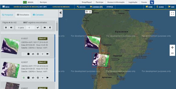
Imagery. INPE Image Catalog is a go-to source of free satellite imagery maps of South and Central America, and Africa only. It features satellite images from Brazil and China’s joint mission, CBERS-4, alongside U.S., UK and India’s Earth-observing missions: Aqua, Terra, Landsat-8, ResourceSat, Suomi-NPP, DEIMOS, and UK-DMC 2. Additional free GIS data from CBERS-2, Landsat 1-3, 5,7 satellites can be found in their a bit dated-looking cadastre.
Search. The catalog is simple and laconic with the only exception that it’s in Portuguese. However, this can be solved with the help of Google Translate for websites. Other than this, the search can be conveniently limited to specific countries/areas, dates, cloud cover %. The found tiles can be previewed on a map, both separately and all at once.
Download. For free satellite imagery download , you need to add images to the cart and order them. The downloading is carried out via an FTP link sent to your email address.
Analysis. This option is not available.
INPE Image Catalog is recommended for users whose main interest lies in South and Central America or Africa. Unfortunately, this service doesn’t provide free global satellite images but, overall, is a good user-friendly option for quick search and download of images that can be later analyzed using another software.
There are many other free satellite imagery sources out there, but we suggest that you start from these top seven free GIS data services for getting the best experience.
Good luck with your search!