تحديث الخرائط الطبوغرافية بمقياس 1: 250000 للأراضي الليبية باستخدام نظام المعلومات الجغرافية باستخدام برنامج (QGIS) والبيانات المكانية مفتوحة المصدر: مشروع طبوغرافية ليبيا
Updating Topographic Maps at Scale 1:250000 for Libyan Territory Using Quantum GIS (QGIS) and Open Geospatial Data: Libya Topo-Project
تحديث الخرائط الطبوغرافية بمقياس 1: 250000 للأراضي الليبية باستخدام نظام المعلومات الجغرافية باستخدام برنامج (QGIS) والبيانات المكانية مفتوحة المصدر: مشروع طبوغرافية ليبيا
Salah Hamad
Faculty of the Natural Resources and Environment Sciences, University of Omar Al Mukhtar, Al Baydah Libya.
Abstract
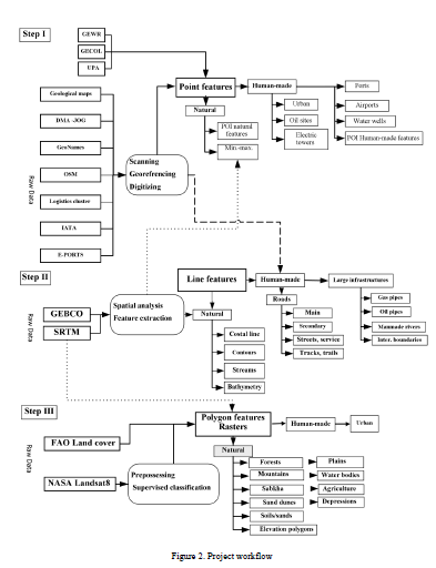
From the beginning of the twentieth century, topographic maps for the Libyan state carried out by various compilers, where the first mapping was carried out by the Italian Military Geographical Institute, the Soviet Union Military, and the U.S. Army, followed by mapping carried out by the Libyan state from the 1950s to the 2000s. Most of these maps have not been digitized and updated using the techniques of geographic information systems and remote sensing. This paper discusses on the objectives, methodology and results of the Libya Topography Project, “Libya Topo” for updating the previously compiled topographical map at scale, 1:250000. Open spatial data from different platforms (OSM, Logistics Cluster, Landsat 8 satellite imagery, and SRTM data, etc.). Also, POIs extracted from previously compiled topographic and geological maps. Spatial database for each UTM zone created to store the features and raster. As for the cartographic style, the map layout adopted is the style of the U.S. Defense Mapping Agency maps. The results of the project are an update of 121 topographical map sheets using Quantum (GIS), those will be freely available for the interested users on request (e.g., environmentalists, academics, and university students, etc.).
1 INTRODUCTION
Topographic maps are essential for geomorphological, regional and local studies and defined as a detailed and precise two-dimensional characterization of the land surface’s distinctive natural and human-made features. They used for various applications such as urban planning, resource management, surveying, and outdoor adventures like hunting, fishing, and racing. The most distinguishing components of the topographic maps are the elevation contours, which are imaginary lines connecting similar elevation, and allow the representation of heights for ridges, hills, and the mountains in addition to the steepness of the slope in three dimensional. Also, the topographic maps contain many symbologies to categorize both human-made and natural features such as roads, buildings, quarries, lakes, streams (Pidwirny, 2009; Kennedy et al., 1987; USGS, 2020; Brock et al., 2002). Topographic maps are the essential types of maps and have passed through many stages of their development and the means of production. Their importance is due to their deepening in different fields, since they represent all the phenomena on the earth’s surface, whether these are human-made or natural. One of the first topographic mappings of large scale began when John Wesley Powell persuaded the U.S. on 4-5 December 1884. Then Congress permitted the U.S. Geological Survey (USGS) to enter systematic mapping of U.S. topography. Twenty-five hundred years later, the mapping techniques have currently moved forward from field surveys to methods based on the computer through photogrammetry. Also, topographical map scales and content have changed, and through that time USGS, compiled maps in scales of (1:250,000 and 1:125,000). The scales extended with time, and through 1894 maximum maps had been created at a scale of 1:62,500. Where the characteristics are shown on the maps included; state, county, town, or village civil divisions, in addition to public utilities, such as tunnels, railroads, wagon roads, trails, bridges, ferries, fords, dams, and canals (Usery et al., 2009; Usery et al., 2018; Kind, 2014). Furthermore, the Soviet Union conducted during the cold war, the most extensive cartographic project in the world during the twentieth century that already covered foreign territories in 1938. Where, the global sheet of International Map of the World System nomenclature adopted for the produced map sheets. The mapping initiative was staggering in scope (Watt, 2005; Kent et al., 2019; Barney, 2014), where the entire world mapped at scales: 1:1 million, 1:500,000 and 1:200,000: Most of Asia, Europe, northern Africa, and North America mapped at scale 1:100,000. USSR and most of Europe, and the Far and Near East at scale 1:50,000; USSR and Eastern Europe at scale 1:25,000. A quarter of the USSR at scale 1: 10,000. The Soviet Union embarked secretly on the most extensive and systematic global mapping project ever undertaken in the Cold War period. Several scales of detailed topographical maps and plans of foreign territories (i.e. 1:5,000, 1:10,000, 1:15,000, 1:25,000, 1:50,000, 1:100,000, 1:200,000, 1:500,000 and 1:1,000,000) were produced by thousands of cartographers working within the Union of Soviet Socialist Republics (USSR) in accordance with standard specifications (Davis and Kent, 2017; Kent et al., 2019). The Soviet Union maps became available to a broader audience as the Soviet Union broke up. It started to appear in international map dealer catalogs. Telecommunications and oil agencies have been eager clients shopping for up Soviet maps of Central Asia, Africa, and other parts of the developing world for which there were often used by aid groups and scientists (Mustard, 2020; Kostelnick, 2018) Moreover, topographical mapping represents a complex process that requires human resources and time. Specialized manner improvement is likewise the conventional approach for updating a country wide topographical map. Many governmental mapping agencies and survey agencies have taken several years to update topographical maps (Wagle and Acharya, 2020). Topographic mapping has developed from field data collection based on ground control surveying and field-sketching the terrain and planimetric features by photogrammetry to digital collection geographic information systems and remote sensing, which have brought considerable progress to map design and production (Usery et al., 2018). The development has reflected in the external and internal layout of the topographic map. Presently many countries developed and updated their historical topographical maps using modern data processing technologies inherent in GIS geographic information systems and based on remote sensing data. Moreover, platforms and map servers also offered many free spatial data, not limited to significant landmarks such as highways, urban areas, interest points, and local geographical names, where this has facilitated the process of updating topographical maps. The U.S. Topo series is an example of topographic mapping updates, where the USGS topographic maps updated to make a new generation of American landscape maps, where the topographic maps of the U.S. Topo created by the U.S. National Geospatial Program of the U.S. Geological Survey (USGS). The project began late 2009, and the word “U.S. Topo” explicitly refers to quadrangle maps launched in 2009 and beyond. Those maps primarily based totally at the acquainted 1947-1992 quadrangle maps of 7.5 minutes. Still, they are mass-produced on a repeated cycle. U.S. from country wide GIS databases, Topo-maps geographic information system: repackaging data in standard map form, aiding non-specialist map users as well as standard map applications (USGS, 2020).
In the early twentieth century, topographic maps accomplished for the Libyan state by the various compiler and some of the produces maps is illustrated, as shown in Table 1. During the Italian occupation period, the Italian Military Geographical Institute carried out the first completed extensive mapping covering all the Libyan territories that followed in the 1940s by the Soviet Union mapping, and the U.S. military mapping in the 1960s. Following the establishment of the Libyan state in the 1950s, the government embarked on several topographical mapping projects by the Libyan Surveying Authority.
Furthermore, the topographical mappings conducted by some Libyan institutions such as:
General water authority
Secretariat of agriculture and land reclamation
Libyan national army
Urban planning authority
These mapping were focused on specific regions or application; geological research, hydrogeology, water resources, and agricultural research. Also, most of these maps have not digitized and updated according to modern techniques of GIS and RS since they do not include, for example, the change in human-made features, urban areas, roads, and electricity networks, etc. Nevertheless, some maps were produced during the 2000s by some foreign geoinformation agencies, which are not published publicly and are restricted to use by some institutions.
Since there are no new editions for the Libyan topographic maps and have not subjected to accurate, comprehensive updates, it is also not in proper format for geospatial software, so this limits the benefit to users of these maps.