التنمية العمرانية في قرى الوحدات المحلية بمحافظة المنوفية: دراسة في جغرافية العمران - سارة السيد عبد الحميد 2022
Settlement Development in Local Units
Villages in EL Menoufia Governorate
A study in Geography of Settlement
Using Geographic Information Systems
and Remote Sensing
رسالة مقدمة
لنيل درجة الماجستير في الآداب من قسم الجغرافيا
بكلية الآداب – جامعة القاهرة
إعداد الطالبة
ساره السيد عبد الحميد معوض
المُعيدة بقسم الجغرافيا – كلية الآداب – جامعة القاهرة
إشراف
أ. د. أشرف علي عبده
أستاذ جغرافية العمران ونظم المعلومات الجغرافية
كلية الآداب – جامعة القاهرة
د. عبد الفتاح السيد عبد الفتاح
مدرس جغرافية العمران ونظم المعلومات الجغرافية
والاستشعار من بعد – كلية الآداب – جامعة القاهرة
القاهرة
2022 م – 1444هـ
الملخص باللغة العربية
التنمية العمرانية في قرى الوحدات المحلية بمحافظة المنوفية دراسة في جغرافية العمران باستخدام نظم المعلومات الجغرافية والاستشعار من بعد
إعداد الطالبة
ساره السيد عبد الحميد معوض
إشراف
أ. د. أشرف علي عبده
د. عبد الفتاح السيد عبد الفتاح
تُعد قرى الوحدات المحلية هي حلقة الوصل بين المدن والقرى التوابع وعند البدء في التفكير في تنمية مجتمع ما لابد من البدء بوحدته الإدارية الصغرى في هيراركية حجمية لتصل في النهاية إلى تنمية المجتمع بأكمله، وتهتم عملية التنمية العمرانية الريفية بإصلاح العديد من جوانب الخلل في المنظومة الريفية ومنها الارتقاء بالبيئة العمرانية والجوانب
الشكلية إلى جانب النسق العمراني للقرية، وهذا مع دراسة متأنية للسكان وفهم احتياجاتهم والعمل على تحقيق التوازن في علاج جوانب الاختلال التي يعاني منها سكان المجتمع الريفي، إضافة إلى امداد القرية بالخدمات اللازمة، لذا فالهدف الأساسي لدراسة قرى الوحدات المحلية هو تحقيق اكتفاء عمراني وخدمي واقتصادي ذاتي وتهيئة هذه القري لتلبي احتياجات القرى التوابع لها وتكون مصدراً رئيسياً لامدادهم بالخدمات والإدارة اللازمة لتوجيه الوحدات الأصغر منها إدارياً من القرى التوابع النجوع والعزب وغيرها من الوحدات الأصغر، هذا وهي أيضاً حلقة الوصل بين القرى التوابع والمدن، فتصبح الوحدة المحلية قادرة على حكم نفسها وإدارة شؤون توابعها بتحقيق اكتفاء خدمي وبيئي وعمراني واقتصادي ذاتي، ولتجنب الضغط على المدن المجاورة لتلك القرى، هذا إلى جانب التوجيه بالاستفادة من موارد هذه القرى على النحو الأمثل.
وتتألف الدراسة من خمسة فصول تسبقها مقدمة وتعقبها خاتمة، وقد اشتملت المقدمة على موقع منطقة الدراسة، أسباب اختيار الموضوع، الدراسات السابقة وأهداف وتساؤلات والمناهج والأساليب المتبعة فيها ومحتوياتها، وفيها أيضاً تم عرض لمراحل الدراسة وتوظيف تقنيات الاستشعار من البعد ونظم المعلومات الجغرافية والمراحل التي مرت بها البيانات داخل كل منهما والبرامج التي تم استخدامها.
وتناول الفصل الأول عرض للتطور العمراني في قرى الوحدات المحلية بمحافظة المنوفية خلال الفترة من 1986 إلى 2018م، من حيث تطور للمساحة العمرانية، واتجاهات النمو العمراني، بالإضافة إلى هيراركية الحجم العمراني في قري الوحدات المحلية والتي تضمنت ترتيب القرى وفق الحجم العمراني وتوزيع أحجام القرى حسب الاتجاهات الرئيسية، ومعرفة أسباب التغيرات الحجمية للكتل العمرانية خلال مراحل الدراسة، والتعرف على الأنماط التوزيعية القائمة للمراكز العمرانية ومدى تكيفها مع ظروف البيئة.
وعرض الفصل الثاني دراسة الإمكانات العمرانية للتجمعات محل الدراسة، وذلك من خلال الوقوف على التركيب العمراني الداخلي والذي يعكس صورة العناصر البنائية التي تكون المحلات العمرانية، فضلاً عن صورة استخدام المباني، وبما يهدف إلى بيان التباين المكاني في تلك العناصر واختلاف توزيعها والعوامل التي أدت إلى ذلك، ويهتم هذا الجزء من الدراسة بإبراز الإمكانات العمرانية في قرى الوحدات المحلية بمحافظة المنوفية على أساس أن الوقوف على حجم الإمكانات العمرانية الحالية للقرى ذو أهمية للتخطيط العمراني الحالي والمستقبلي، وسوف يتم ذلك من خلال الوقوف على التركيب العمراني الداخلي لتلك القرى، واستخدامات المباني بها.
وناقش الفصل الثالث البيئة الإسكانية في قرى الوحدات المحلية بمحافظة المنوفية، بالوقوف على خصائص الوحدات السكنية من نصيب الفرد من المساحة السكنية ونوع الحيازة ودرجة التزاحم، ثم عرض لخدمات البنية الأساسية وتناول فيها الطرق ومياه الشرب والصرف الصحي وشبكة الكهرباء، ثم الخدمات التعليمية وناقش فيها حال الخدمات في المراحل التعليمية ما قبل التعليم الجامعي بدءاً من مرحلة رياض الأطفال وحتى التعليم الثانوي العام والفني، وانتهي الفصل بدراسة واقع الخدمات الصحية بالقرى محل الدراسة.
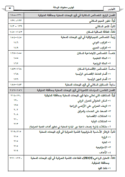
وجاء الفصل الرابع بدراسة الخصائص السكانية في قرى الوحدات المحلية بمحافظة المنوفية، حيث عرض الهيكل السكاني في إطار جغرافية العمران داخل قرى الوحدات المحلية من خلال دراسة النمو السكاني، والكثافة السكانية، والتركيب النوعي والعمري للسكان، والخصائص الاجتماعية للسكان من حيث الحالة التعليمية والحالة الزواجية، كما نافش الفصل الخصائص الاقتصادية للسكان أقسام النشاط الاقتصادي الرئيسية وكذلك أقسام المهن الرئيسية، هذا فضلاً عن دراسة المستقبل السكاني في القرى محل الدراسة من خلال مقارنة ثلاثة احتمالات توضيح الأرجح منها.
واختص الفصل الخامس بمناقشة السياسات التنموية في قرى الوحدات المحلية بمحافظة
المنوفية، وأهتم بتوضيح مفهوم التنمية العمرانية الريفية، والمشكلات التي تعاني منها قرى الوحدات المحلية بالمحافظة، ثم الركائز الأساسية لاستراتيجية التنمية العمرانية وترابطها مع جوانب التنمية الأخرى في قرى الوحدات المحلية بعناصرها من حيث تحديد الرؤية التنموية والغاية التي تهدف إليها الدراسة وطرق تحقيقها وتنفيذها على أرض الواقع الفعلي للبيئة الريفية الحالية، والأهداف التي نطمح إليها مع تقديم نموذج مُقترح لاستراتيجية التنمية العمرانية في قرى الوحدات المحلية، ثم بعد ذلك عرض التحليل الرباعي لقطاعات التنمية العمرانية مع التركيز على نقاط القوة والضعف والفرص والمخاطر، إضافة إلى ذلك توضيح أساليب التنمية العمرانية وآليات تنفيذ مشروعات التنمية المقترحة للارتقاء بالبيئة الريفية بمساندة الحكومة واقتراح إعادة ترتيب الهيكل الإداري والتنفيذي للقرية للوصول إلى أفضل استفادة ممكنة، وتوضيح مصادر التمويل التي يمكن الاعتماد عليها في عملية التنمية وضرورة المشاركة الشعبية لتنمية المجتمع المحيط بهم.
وانتهت الدراسة بخاتمة وفيها عرض لأهم نتائج الدراسة التي خلصت إليها وأهم التوصيات.
Settlement Development in Local Units Villages
in EL Menoufia Governorate
A study in Geography of Settlement
Using Geographic Information Systems
and Remote Sensing
Thesis Submitted For Obtaining Master Degree from Geography Department,
Faculty of Arts, Cairo University.
Prepared By
Sara El Sayed Abdel Hamid Moawad
Demonstrator at Geography Department Faculty of Arts – Cairo University
Supervision:
Prof. Dr. Ashraf Ali Abdou
Professor of Geography of Settlement & Geographic information systems,
Geography Department, Faculty of Arts, Cairo University.
Dr. Abdel Fattah El Sayed Abdel Fattah
Doctor of Geography of Settlement, Geographic information systems &
Remote Sensing, Geography Department, Faculty of Arts, Cairo University
Cairo
2022 - 1444
Summary
Settlement Development in Local Units Villages in Menoufia Governorate: A study in Geography of Settlement Using Geographic Information Systems and Remote Sensing
Prepared by:
Sara El-Sayed Abdel Hamid Moawad
Supervised by:
Prof. Dr. Ashraf Ali Abdou
Dr. AbdelFattah ElSayed
AbdelFattah
Local units villages are considered the link between cities and satellite villages and when one starts thinking of developing a particular society, must start with its smallest administrative unit in a volumetric hierarchy to eventually achieve the development of the whole society. The process of rural settlement development is concerned with reforming multiple aspects of the imbalance in the rural system, such as upgrading its housing environment and formal aspects as well as the village’s settlement layout, by providing a careful study of the population, understanding their needs, and working on restoring balance to this rural society, as well as providing the village with necessary services.
The main objective of studying the villages of the local units is to help them achieve self-sufficiency in services, and economy and to prepare
these villages to meet the needs of their satellite villages and be their main supplier of the necessary services and management, to guide the administratively smaller units of the satellite villages, hamlets, homesteads, and other smaller units. They’re also the link between the cities and the satellite villages, thus, the local unit is able to govern itself and manage its vassals by achieving service, environmental, settlement and economic self-sufficiency and avoiding pressure on the villages’ neighboring cities, in addition to reach the best use of the resources of these villages.
The study consists of five chapters, preceded by an introduction, and followed by a conclusion. The introduction includes the study area’s location, the purpose of the chosen topic, literature review of previous studies, objectives, and questions, as well as the methods followed in the study and its contents. It also displays the study’s phases, utilizing
the technicalities of Remote Sensing and Geographical Information Systems (GIS), and the stages through which the data went in each one of them and the softwares used.
Chapter I, presents the growth in the villages of the local units in Menoufia governorate, during the period from 1986 to 2018, by tracing the development of the settlement area, settlement growth trends, as well as the settlement volumetric hierarchy in the villages of the local units. This includes the arrangement of villages according to their settlement size and distributing the villages’ size according to the main directions, knowing the causes of the change in the settlement masses’ sizes during the study period, identifying the existing distributional patterns of settlement centers and the extent of their adaptation to environmental
conditions.
Chapter II, provides a study of the settlement clusters' potentials in the study area, which is studied by analyzing the internal structure of the settlement that reflects the nature of the structural elements that forms the settlement areas, as well as the usages of these buildings with the aim of showing the spatial variance in those elements and the difference in their distribution and the factors that lead to that. This section of the study is concerned with showing the settlement potentials of the villages in the local units of Menoufia governorate. It is important to focus on the current settlement potentials of these villages because this will help in current and future settlement planning, which will be done by examining the internal settlement structure of those villages, and the uses of the buildings in them.
Chapter III, discusses the housing
environment in local units villages in Menoufia Governorate, by examining the characteristics of the housing units; including the per-capita share of the housing area, the possession type, and the severity of crowding, as well as tracing the infrastructure services, roads, drinking water, sewage system, electrical network, and educational services, which includes the pre-university educational stages – starting from kindergarten to general and technical secondary education. The chapter ends with the study of health services in the villages under study.
Chapter IV, presents a study of the population characteristics in the villages of
local units in Menoufia Governorate, where the population structure is presented within the framework of settlement geography within the villages of local units through the study of population growth, population density, the qualitative and age composition of the population, and the social characteristics of the population in terms of educational and marital status. The chapter also discusses the economic activities of the population, the main sections of economic activity, as well as those of professions. Additionally, the thesis studies the future of the population in the concerned villages by comparing three possibilities to highlighting the most likely ones.
Chapter V, is devoted to discuss the development policies in the villages of the local units’ in Menoufia Governorate, it also sheds light on the definition of “Rural Settlement Development”, and the issues from which the local unit’s villages suffer in the governorate, then the essential pillars of the settlement development strategy and its correlation with other aspects of development in the local units’ villages with its elements in terms of defining the developmental
vision, the purpose of the study and ways to achieve and implement this vision in the current rural environment, as well as the goals we aim to achieve. The study also presents a model for the settlement development strategy in the local units’ villages, and then provides a quaternary analysis of the settlement development sectors by concentrating on points of strengths, weaknesses, as well as opportunities, and risks. In addition to this the study sheds light on the methods of settlement development and the mechanisms for implementing the proposed development projects to improve the rural environment with the government’s support, the suggestion to rearrange the administrative, and executive structure of the village to reach optimal use, and to state the reliable funding sources in the development process and the need for the contribution of the population to the development of their community.
Finally, the study ends with a conclusion that contains its most crucial findings and thesis recommendations.
تحميل الرسالة
drive.google-download
mega.nz/file-download
للاطلاع والتحميل الرسالة