التقييم الكمي للجريان السطحي في وادي الكراث طبرق شمال شرق ليبيا
دراسة هيدرومورفومترية
د. علاء جابر فتح الله الضراط
جامعة طبرق/ كلية التربية


مجلة جامعة صبراتة العلمية - المجلد 4 - العدد 2 - ديسمبر 2020م - ص ص. 49 - 66 :
الملخص:
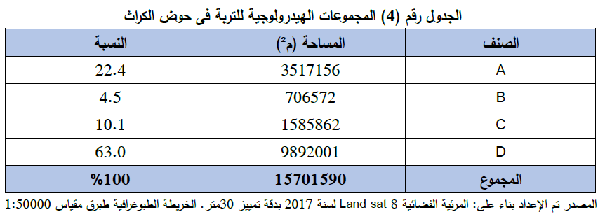
يعد حوض وادي الكراث من الأودية موسمية الجريان، إذ تبلغ مساحته (15701590م²) ويقع في نطاق بلدية طبرق شمال شرق ليبيا، واعتمدت هذه الدراسة تقنية التحسس النائي لتحديد أنواع الغطاءات الأرضية لمنطقة الدراسة، بناء على فرضية صيانة التربة الأمريكية (SCS-CN) لتقديرحجم الجريان السطحي في الحوض، إلى جانب الخريطة الطبوغرافية طبرق مقياس 1:50000، والقياسات الميدانية لصغر حجم الحوض وعدم وضوح بعض الخصائص الطبيعية، وتبين من خلال الدراسة أن (48%) من مساحة الحوض قليلة النفاذية ما يساعد على توليد الجريان السطحي في زمن قصير من عاصفة مطرية واحدة، وعند هطول أعلى عاصفة مطرية (77.7ملم ) قد بلغ حجم الجريان السطحي على الحوض (494600م³) بسرعة جريان سطحي بلغ (1.48م³/ ثانية) وبلغ زمن التركيز (31 دقيقة) وهو وقت قصير جداً يزيد من مخاطر السيول عند سقوط الأمطار الفجائية التي تتميز بها منطقة الدراسة.
الكلمات المفتاحية: التقييم الكمي - الجريان السطحي - وادي الكراث طبرق.
Quantitative assessment of surface runoff in Al - Karath valley, Tobruk, northeastern Libya Hydro Morphometric study
Abstract:
The Al-Karath Valley basin is one of the Valleys of seasonal flow with the area of (15701590m²) located within the domain of the municipality of Tobruk, northeast of Libya, The study is based on the technique of remote sensing to determine the types of soil cover of the study area, relying on the American soil conservation hypothesis, known as (SCS-CN), in order To estimate the size of surface runoff in the basin considering the highest rainstorm that hit it, In addition, The study in this regard, relies on the topographic map of Tobruk with the scale of ( 1: 50,000), as well as, the field measurements, because of the small size of the basin and the lack of clarity of some natural characteristics. It has been shown through the study that (48%) of the basin area has low permeability that helps to generate the surface runoff in a short time from one rainstorm. The runoff volume of the highest rainstorm has reached (77.7 mm) fell on the basin with the volume of (494,600 mᶟ) and at a surface flow velocity of (1.48 mᶟ /s) The concentration time (31 min) which is a very short time that increases the flood risks when sudden rain falls; a case that is distinguished in area of the study.
Keywords: Quantitative Assessment - Surface RunoffAl - Karath Valley- Tobruk.