تأثير حركة المياه البحرية على ساحل منطقة طبرق شمال شرق ليبيا - دراسة في الجيومورفولوجيا
د. علاء جابر فتح الله الضراط
أستاذ مساعد بقسم الجغرافيا / كلية التربية
جامعة طبرق

مجلة ليبيا للدراسات الجغرافية- الجمعية الجغرافية الليبية - فرع المنطقة الوسطى - العدد الرابع - يناير 2023م – ص ص. 27 - 43:
الملخص:
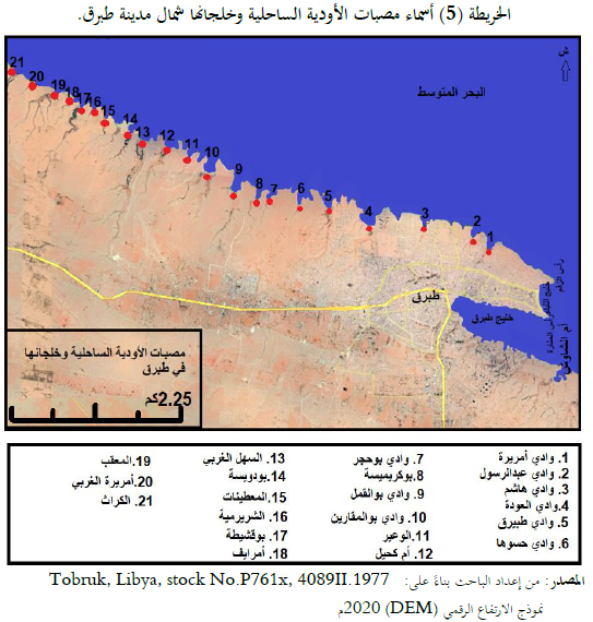
تشرف منطقة الدراسة على البحر المتوسط بساحل بلغ طوله 52.42 كم، وتمثل التداخلات الساحلية أحد أشكال الساحل المميزة له نظراً لانتشارها على طول الساحل وتوغل البحر في اليابس لمسافات متباينة، وأبرزها خليج طبرق البالغ مساحته 6.47 كم 2، وتهدف الدراسة إلى تحديد خصائص الساحل والعوامل المؤثرة في تشكيله.
تعرَّض ساحل منطقة الدراسة خلال الفتًرات الجليدية والفتًرات الدافئة في عصر البلايستوسين لتذبذب مستمر، وارتبط منسوب سطح البحر بالتغيرتات المناخية – النباتية في الزمن الرابع، وكذلك هناك عوامل أخرى منها: التكتونية مثل توازن القشرة الأرضية وبناء الجبال والتواء سطح الأرض، حيث كان الغمر البحري بالفتًرات الدافئة التي تتخلل الفتًرات الجليدية، والعكس أثناء فتًرات البرودة الشديدة أو الجليدية. وترجع أقدم التكوينات الجيولوجية بمنطقة الدراسة إلى عصر الإوليجوسين العلوي والميوسين السفلي بالزمن الثالث، وأحدث التكوينات ترجع إلى البلايستوسين بالزمن الرابع.
وبدراسة خصائص خط الساحل تراوحت نسب التعرج به ما بين 5.6 /كم عند خليج طبرق إلى 1.3 /كم في الساحل الممتد من رأس الزقم حتى مصب وادي العودة، بمتوسط عام بلغ 2.55 / كم. في حين تراوحت معدلات التقوس في الساحل 0.48 عند خليج طبرق إلى 2.6 عند شاطئ الليدو بمتوسط عام بلغ 2.06، ويشير ذلك على استقامة الساحل، وذلك بسبب العوامل البنائية المختلفة سواء كانت تكتونية أو بفعل عوامل التعرية البحرية، وتحكمت طبيعة الساحل واتجاهاته في التداخلات البحرية في اليابس.
وتبين من خلال دراسة العوامل المؤثرة في تشكيل الساحل أن الأمواج السائدة واتجاهاتها والتي تراوحت قوة طاقتها ما بين 5062 كجم/ م 2 صيفاً إلى 125577 كجم/م 2 في فصل الشتاء، والتي كان لها الأثر الواضح في كمية الرواسب المتاحة في تحديد حجم ونمط الأشكال الناتجة عن النحت والإرساب البحري. كما تبين من خلال مسارات التيارات البحرية التي تسير على أعماق تراوحت ما بين 50 – 100م فيقل تأثيرها على خط الساحل لأنها موازية له، وكذلك يبعد مسارها عن خط الساحل لمسافة 3كم في التوسط، وتبين من دراسة حركتي المد والجزر تأثر الساحل بنظام المد والجزر النصف يومي وهو لا يتعدى 30 سم ويقتصر تأثيره على منطقة الجروف البحرية في شمال غرب منطقة الدراسة.
الكلمات المفتاحية: التداخلات الساحلية، الجروف البحرية، الأمواج الساحلية.
The effect of marine water movement on the coast of Tobruk, northeastern Libya - a geomorphological study
Dr. Alaa Jaber Fathallah Al-Darrat
Assistant Professor Department of Geography, Faculty of Education, University of Tobruk alaa.al-darat@tu.edu.ly

Abstract:
The study area is supervised the Mediterranean Sea, with a coastline of 52.42 km, the coastal meanders are one of the distinctive forms of the coast, due to their spread along the coast and the penetration of the sea into the dry land for varying distances. The most notable one of these meanders is the Gulf of Tobruk, which has an area of 6.47 km2. The study aims to determine the characteristics of the coast and the factors affecting its formation.
During the glacial periods and warm periods in the Pleistocene era, the coast of the study area was subjected to continuous fluctuation, and the sea level was associated with climatic changes - vegetation in the quaternary, as well as other factors, including: tectonics such as the balance of the earth's crust, the construction of mountains and the torsion of the earth's surface, where marine submersion was during the warm periods during glacial periods, and vice versa during extreme cold or icy periods. The oldest geological formations in the study area date back to the upper Oligocene and lower Miocene in the Cenozoic, and the most recent formations date back to the Pleistocene in the quaternary.
And by studying the characteristics of the coastline, the meandering rates ranged from 5.6/km at the Gulf of Tobruk to 1.3/km at the coast extending from Ras al-Zaqqm to the mouth of al-Awda Valley, with a general average of 2.55/km. The curvature rates in the coast ranged from 0.48 at the Gulf of Tobruk to 2.6 at the Lido Beach, with an average of 2.06. This is due to the various structural factors, whether they are tectonic or by marine erosion factors, and the nature and directions of the coast control the marine interference in the land.
By studying the factors affecting the formation of the coast, it was found that the prevailing waves and their directions, whose energy strength ranged from 5062 kg / m 2 in summer to 125577 kg / m 2 in winter, which had a clear effect on the amount of sediment available in determining the size and pattern of shapes resulting from marine sculpture and sediment.
It was found, through the paths of the sea currents that travel at depths ranging between 50-100 m, that their impact on the coast line is minimized, because they are parallel to it, and because their path is away from the coast line for an average distance of 3 km. It was also found, by studying the two tidal movements, that the coast was affected by the semi-daily tidal system, which does not exceed 30 cm, and its effect is limited to the marine cliffs area in the northwest of the study area.
Keywords: marine interference, marine cliffs, coastal waves.